
Products / GeoSite
Turn Dispersed Intelligence Into a Clearer Operational Picture.
A secure intelligence platform for defence, government, public safety, and critical-infrastructure teams. It combines satellite imagery, open-source intelligence, entity data, and historical records so analysts can monitor priority areas, assess change, and brief decision-makers with greater context.
- Defence & Gov
- Public Safety
- Critical Infrastructure
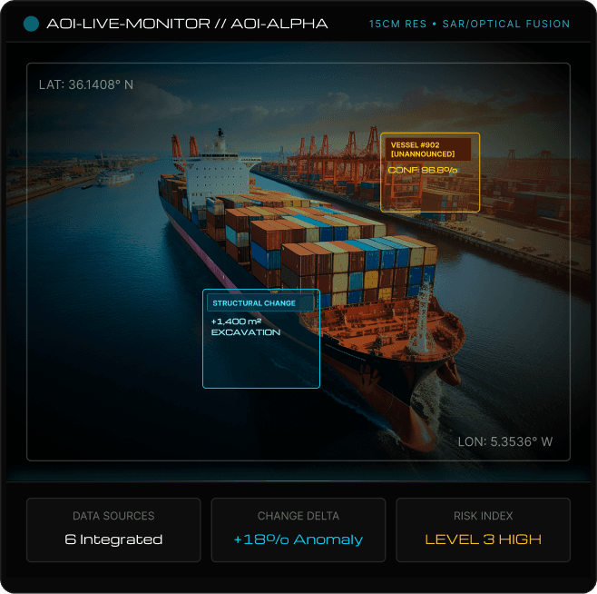
Data sources
6 Integrated
Change delta
+18% Anomaly
Risk index
Level 3 High
- Priority-Area Monitoring
- Change Detection
- Multi-Source Analysis
- Entity & Relationship Mapping
- Pattern Analysis
- Analyst Workspaces
- Alerts and Escalations
- Intelligence Briefs
Platform overview
An Integrated Environment for Monitoring, Analysis, and Intelligence
The platform gives intelligence teams a shared environment to examine what is happening across locations, people, organisations, infrastructure, vehicles, landmarks, symbols, incidents, and other entities of interest.
What Goes Into the Platform
Multi-source intelligence aggregation
- Satellite & aerial imagery
- Open-source intelligence (OSINT)
- Incident & field reports
- Entity & vessel records
- Historical intelligence archives
What Analysts Do With It
Spatial, temporal & relationship analysis
- Monitor strategic priority areas
- Compare temporal change over time
- Investigate multi-source relationships
- Examine spatial patterns & trends
- Assess significance of emerging activity
What the Platform Produces
Actionable briefings & mapped records
- Mapped geospatial intelligence
- Prioritised risk alerts & anomalies
- Structured investigation records
- Concise briefs for decision-makers
Who it serves
Built for Teams That Need to Understand What Is Happening, Why It Matters, and What to Do Next.
Border and Territorial Awareness
Follow activity across borders, remote regions, access routes, and sensitive zones.
- Border Sectors
- Access Routes
- Remote Outposts
- Buffer Zones
Defence and Intelligence Agencies
Monitor strategic areas, examine emerging activity, and support operational or command-level assessment.
- Port Terminals
- Anchorage Zones
- EEZ Waterways
- Offshore Assets
Critical-Infrastructure Operators
Monitor activity around energy, transport, telecommunications, water, and other essential assets.
- Substations
- Pipeline Corridors
- Water Basins
- Data Hubs
Public Safety and Crisis-Response Units
Maintain situational awareness during emergencies, civil incidents, and fast-moving events.
- Evacuation Corridors
- Impact Zones
- Response Hubs
- Staging Grounds
Intelligence Analysts
Compare sources, review imagery, investigate entities, and prepare evidence-based assessments.
- Entity Records
- Satellite Imagery
- Relationship Graphs
- Historical Reports
Senior Leadership
Receive concise intelligence briefs that explain the event, its context, and the level of attention required.
- Executive Briefings
- Risk Summaries
- Priority Alerts
- Strategic Reports
Outcomes
More Than Where an Event Happened.
Location is only one part of an intelligence assessment. The platform helps teams understand the activity around that location, how it has changed, who may be connected to it, and whether it forms part of a wider pattern.

The platform answers
What Has Changed?
Compare current and historical imagery, incidents, and activity across a selected area.
How it works
From Incoming Data to an Analyst-Reviewed Assessment.
A structured six-stage pipeline transforms raw satellite imagery and multi-source intelligence feeds into human-validated, prioritized executive briefings.
01Monitor Phase
The platform receives approved satellite imagery, drone feeds, incident reports, public news/social feeds, entity records, and field inputs linked to selected areas of interest (AOIs).
Full audit logging & analyst attribution enforced
Phase inputs
- Satellite/Aerial Imagery
- Live OSINT Feeds
- Field Telemetry
Key target assets
- Unified Geospatial Layer
- Area Activity Stream
Analysis layers
The Platform Examines What Is Visible, What Has Changed, and What Surrounds It.
Visual Intelligence
Reads satellite and aerial imagery to surface what is visible in a priority area.
Temporal Intelligence
Compares imagery and records over time to show what has changed.
Contextual Intelligence
Places activity beside entities, routes, assets and earlier incidents.
Escalation Scoring
Brings the available indicators together into a prioritized risk score for analyst and leadership review.
- Human-In-The-Loop Assurance
Capabilities
Everything Needed to Examine Activity Across Place, Time, and Context.
- Geospatial
Priority-Area Monitoring
Track selected borders, maritime routes, key facilities, critical regions, and strategic assets through a unified tactical map.
- Computer Vision
Change Detection
Compare high-resolution satellite imagery and incident records across time to spot subtle developments that require human examination.
- Data Fusion
Multi-Source Analysis
Review satellite imagery, field incident reports, public information, and entity records inside a single unified spatial assessment view.
- Knowledge Graph
Entity & Relationship Mapping
Connect people, organizations, locations, vessels, assets, and historical events across the wider intelligence picture.
- Analytics
Pattern Analysis
Identify repeated activity cycles, linked events, logistics flows, and developing operational trends across monitored zones.
- Workflow
Analyst Workspaces
Organize raw evidence, annotations, source citations, imagery cutouts, and notes within structured investigation records.
- Real-time
Alerts and Escalations
Notify authorized command teams instantly when selected risk indicators, movement thresholds, or review criteria are met.
- Reporting
Intelligence Briefs
Convert assessed findings into concise executive summaries, mapped export packages, and decision briefings.
Sectors
A Common Intelligence Layer Across Different Security and Operational Priorities.
Border and Territorial Awareness
Monitor routes, crossings, remote areas, and changes around strategic boundaries.
Ports and Maritime Monitoring
Review vessel activity, coastal movement, port operations, and surrounding infrastructure.
Critical-Infrastructure Protection
Maintain awareness around power, transport, utilities, communications, and other essential assets.
Public Safety and Emergency Response
Support coordination during natural disasters, civil incidents, and time-sensitive emergencies.
Aviation and Transport Corridors
Monitor airports, rail networks, logistics routes, and high-value transport infrastructure.
Government and Strategic Sites
Track activity around restricted facilities, administrative centres, and sensitive locations.
Partners shaping the frontier together
- Liberia Special Economic Zone Development Company
- TRACOM Liberia Inc.
- Panchariya Group
- Vintage Cigars
- Wave Capital Ltd
- Westzane Security (Liberia) Ltd
- SavWave Bank Commerce
- Looks Cosmetic Clinic
Don’t just take our word for it
Frequently Asked Questions
Have more question? Reach out to our sales team
What is this platform used for?
Monitoring selected locations, comparing change, investigating related activity, and preparing intelligence assessments for government and critical-infrastructure teams.
Is it only a mapping platform?
No. The map is the visual layer, supported by imagery analysis, entity research, pattern identification, alerts, investigation records, and briefing.
Does the platform make decisions automatically?
No. AI helps identify changes and organise information, but authorised analysts remain responsible for assessments and decisions.
Can it use existing intelligence data?
Yes. It can connect with approved imagery, incident records, entity databases, archives, and operational systems.
Can it operate without public cloud services?
Yes. On-premise, sovereign, and air-gapped deployments can be considered for restricted environments.
Can different agencies work on the same platform?
Yes. Access controls allow multiple teams or agencies to share the environment while protecting sensitive sources and records.
Can the platform be configured for a specific country or mission?
Yes. Monitored areas, data sources, indicators, workflows, user roles, and reporting can be configured.
Digital Systems With More Intelligence, Security and Control.
PCS builds technology for governments, institutions and enterprises where software, data, infrastructure and operations work as one system.
Request a DemoGlobal presence
Where we operate.
Our strategic offices across key regions enable us to serve our clients. Choose an office to turn the globe.
Next step
Tell us what you need to protect.
Share the service area, expected scope and any timeline. We’ll review it and come back with the appropriate next step — a proposal, a capability presentation, or a review of an existing programme.
- Phone
- +44 7387 119386
Active incident? Call +44 7387 119386 or email us. Please don’t send credentials or sensitive data in writing.