
Products / CropBurn
Manage Burn Activity From Detection to Field Closure.
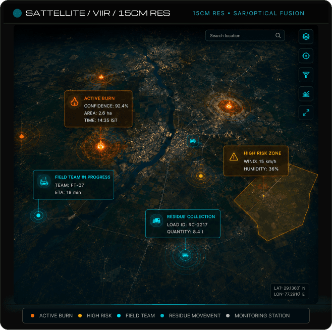
A digital platform for authorities, field teams, agricultural bodies and environmental agencies responsible for burn monitoring, compliance and crop-residue management. It brings incident detection, weather information, field action and residue movement into one operating view.
- Defence & Gov
- Public Safety
- Critical Infrastructure
Signal
Active burns
Focus
High-risk zones
Status
Field teams
- Burn Detection
- Incident Mapping
- Weather Assessment
- Field Assignment
- Compliance Management
- Residue Listings
- Collection Coordination
- Programme Reporting
Platform overview
One Environment for Burn Monitoring and Crop-Residue Management.
Bring burn alerts, weather information, field activities and crop-residue management into one operating environment to coordinate response, monitor compliance and support sustainable residue utilisation.
What Enters the Platform
Burn & field data
- Satellite Burn Alerts
- Weather Information
- Farm & Land Records
- Field Inspection Reports
- Compliance Notices
What Teams Do With It
Response & coordination
- Review Burn Incidents
- Assess Spread Risk
- Assign Field Teams
- Record Compliance Actions
- Monitor Case Progress
What the Platform Produces
Programme outputs
- Mapped Burn Incidents
- Response Status Tracking
- Compliance Records
- Residue Availability Reports
- Operational Intelligence Dashboards
Who it serves
For Teams Responsible for Burn Control, Field Action and Residue Use.
The platform supports authorities, field teams and programme stakeholders responsible for burn monitoring, incident response, compliance management and crop-residue coordination across regions.
- Environment
Environmental Authorities
Monitor burn activity, review incident patterns and maintain oversight across selected regions.
- Agriculture
Agriculture Departments
Coordinate with farmers, local officers and field teams across agricultural areas.
- Emergency response
Fire and Emergency Services
Receive incident information, assess location and conditions, and support response planning.
- Local government
Local and Regional Administrations
Assign cases, follow field activity and maintain records across districts or municipalities.
- Residue network
Residue Buyers and Processors
Review available material and coordinate procurement for energy, fertiliser or industrial use.
- Leadership
Programme Leadership
Track incident volumes, response progress, compliance activity and residue movement across the programme.
Capabilities
Everything Needed to Manage the Incident and the Residue Around It.
- Detection
Burn Detection
Identify and map burn activity across selected agricultural, industrial or rural areas.
- Mapping
Incident Mapping
Place each event within its farm, site, district and surrounding operating context.
- Weather
Weather Assessment
Review wind, temperature and other conditions relevant to spread and response planning.
- Response
Field Assignment
Send incidents to responsible teams and maintain ownership throughout the case.
- Compliance
Compliance Management
Record inspections, notices, action taken, supporting evidence and case closure.
- Residue
Residue Listings
Register available crop residue with material, quantity, location and collection details.
- Coordination
Collection Coordination
Manage interest, pickup status, transport activity and handover between participants.
- Reporting
Programme Reporting
Review incident trends, response performance, compliance activity and residue movement.
Lifecycle
From First Detection to Recorded Resolution.
Receive burn alerts, assess the situation, coordinate field response, maintain compliance records and manage crop residue through one connected operational workflow.
01Detect
Receive burn alerts from approved satellite sources, field teams or authorised reports. Each alert is recorded within the appropriate geographic area, creating a single incident record ready for assessment and operational response.
Burn incident securely recorded and ready for assessment.
Phase inputs
- Satellite Alerts
- Field Reports
- Authorised Reports
Key target assets
- Incident Record
- Geographic Area
02Assess
Review the incident location alongside weather conditions, land use and surrounding assets. Available incident information is brought together to help teams understand potential spread, operational impact and response requirements.
Incident assessed using environmental and operational context.
Phase inputs
- Weather Information
- Land Use
- Surrounding Assets
Key target assets
- Risk Assessment
- Incident Context
03Assign
Send the incident to the responsible local officer, inspection team or emergency unit. Responsibility is established early so field activities can be coordinated and progress tracked throughout the case.
Responsibility assigned and field response initiated.
Phase inputs
- Local Officers
- Inspection Teams
- Emergency Units
Key target assets
- Assigned Team
- Response Status
04Respond
Record field findings, notices, photographs, action taken and any continuing risk within the same incident record. All operational updates remain connected, providing a complete history of field activity.
Field actions and supporting evidence securely maintained.
Phase inputs
- Field Findings
- Photographs
- Notices
Key target assets
- Action Record
- Evidence Repository
05Close
Confirm that the incident has been resolved and retain the evidence required for reporting or compliance. Closure records remain linked to the case, creating a complete and auditable incident history.
Incident formally closed with complete supporting records.
Phase inputs
- Resolution Evidence
- Compliance Records
- Closure Review
Key target assets
- Case Closure
- Compliance Evidence
06Route Residue
List available crop residue and coordinate collection, transport and onward use. Material movement is recorded from availability through collection, supporting continued oversight of the residue network.
Crop residue routed and tracked through the collection network.
Phase inputs
- Residue Listings
- Collection Requests
- Transport Activity
Key target assets
- Material Movement
- Collection Status
Platform capabilities
Everything Teams Need in One Connected Platform.
Detection Intelligence
Identify or receive burn events from approved sources and place each incident within the correct geographic area. Every alert is linked to the relevant operational context, creating a structured starting point for assessment.
Environmental Context
Review weather conditions, terrain, land use and nearby infrastructure alongside every reported incident. Bringing environmental information together helps teams assess potential spread and operational impact.
Response Intelligence
Track responsibility, field progress, supporting evidence and the status of every reported event. A connected case record provides visibility from assignment through final resolution.
Compliance Management
Maintain inspections, notices, field updates and closure evidence within the same incident record. This provides a complete history for operational review and compliance reporting.
Residue Intelligence
Record material availability, collection requirements, buyer interest and final movement after an incident is resolved. Residue information remains connected to the operational workflow from listing through utilisation.
Programme Coordination
Connect incident management, field response and residue coordination within one operating environment, while authorities retain control of response and case closure.
Key questions
Understand Every Incident, Risk and Response.
The platform answers
Where Is the Incident?
Locate reported or detected burn activity within the relevant farm, site, district or operating area.
How it works
From First Detection to Recorded Resolution.
Role views
Every User Sees the Programme from Their Role.
- View 1
Control-Room View
See active incidents, priority areas, response status and unresolved cases across regions from a central operational dashboard.
- View 2
Field-Officer View
Receive assigned incidents, location information, response instructions and evidence requirements for every field activity.
- View 3
Compliance View
Review notices, inspections, action history and cases requiring further follow-up within a connected compliance record.
- View 4
Residue-Network View
Manage residue listings, collection requests, buyer interest, transport activity and final material handover.
- View 5
Leadership View
Track programme activity, regional trends, field performance and residue movement through executive reporting and operational dashboards.
Partners shaping the frontier together
- Liberia Special Economic Zone Development Company
- TRACOM Liberia Inc.
- Panchariya Group
- Vintage Cigars
- Wave Capital Ltd
- Westzane Security (Liberia) Ltd
- SavWave Bank Commerce
- Looks Cosmetic Clinic
Don’t just take our word for it
Frequently Asked Questions
Understanding the Burn and Residue Management Platform
Have more question? Reach out to our sales team
What is the platform used for?
It helps authorities detect and manage burn activity, coordinate field response, maintain compliance records and organise crop-residue collection and use.
Does the platform detect fires automatically?
It can receive approved satellite or system-generated alerts. Field reports and authorised manual incident entries can also be included.
Does the platform replace emergency or field teams?
No. It provides information, assignment and case-management support. Response and enforcement remain with the responsible authorities.
How is weather information used?
Weather data helps teams assess spread risk, prioritise incidents and plan field activity.
Can farmers and residue buyers use the platform?
Yes. Relevant participants can be given controlled access for residue listing, collection and procurement activities.
Can it connect with existing government systems?
Yes. Subject to technical review, it can connect with approved agriculture, environmental, land, weather and emergency systems.
Which deployment models are available?
The platform can support cloud, on-premise, hybrid and sovereign deployment according to programme requirements.
See Burn Response and Residue Coordination in One View.
Share the regions, agencies, field processes, and residue network in your programme. PCS will demonstrate how the platform supports monitoring, response, and ongoing oversight.
Request a DemoGlobal presence
Where we operate.
Our strategic offices across key regions enable us to serve our clients. Choose an office to turn the globe.
Next step
Tell us what you need to protect.
Share the service area, expected scope and any timeline. We’ll review it and come back with the appropriate next step — a proposal, a capability presentation, or a review of an existing programme.
- Phone
- +44 7387 119386
Active incident? Call +44 7387 119386 or email us. Please don’t send credentials or sensitive data in writing.